
Websites to educate and engage residents about urban development and planning projects. Map-based surveys for the past, present, and future of a place and get public feedback.
A creative agency for the built environment
Graphics
Digital and print communication is important to brand, advertise, and explain planning projects. Infographics and explainer videos have a higher response rate than a photo alone.
Visualization
Complex information is easily understood through visualization. Timelines, streetscapes, and 3D models help planners tell a story. Augmented and virtual reality are emerging immersive tools.
Website Development
We develop WordPress websites for planning and transportation projects.
PlaceVision, a nationally recognized web communications firm, was founded in 2006 to help urban planners communicate effectively online with stakeholders through consulting, websites, applications, and visualization tools for the planning, development, and preservation of the built environment.
Communication and presentation materials can be used to help build stronger and better-informed communities. We have the products and skills to help everyone involved understand the issues better and provide valuable feedback.
PlaceVision is a WBE, DBE, and WOSB. The firm works on projects nationally and is headquartered in St. Augustine, Florida.
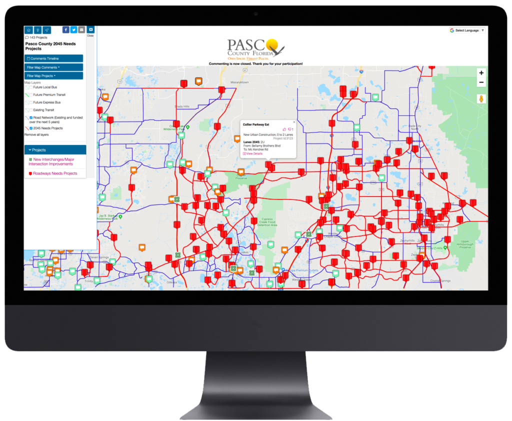
Interactive Maps
PlaceVision works with urban planners that are really good at what they do, but struggle to fully utilize web-based technologies to engage more citizens in the planning process. Two common concerns are:
(1.) Being able to effectively reach different age groups, engage them, and increase public input
(2.) Capture place-based comments to learn more from people about specific locations.
If either of these concerns sound familiar, PlaceVision can help you implement an approach and strategy that has dramatically increased public participation. More planners are turning to COMMUNITY REMARKS over costly MetroQuest. Get up and running within hours to capture feedback instantly.
Historic Preservation Surveys
PlaceVision works with historic preservation firms that need to survey neighborhoods and districts for a National Register nomination, visualize redevelopment opportunities, or manage existing historic districts. Preservationists need a cloud-based platform to:
(1.) Survey properties from the field and upload pictures
(2.) Collaborate, crowdsource, and manage an online building inventory over time
It is an affordable and user-friendly platform to get started quickly and continuously leverage.

“While Ms. Wilson’s work speaks for itself, I also would like to note her responsiveness. Corresponding with her at least once per week, Ms. Wilson makes herself fully available to further the [planning] effort; she is the consummate team player.
We often give her much information to place on the website within a short timeframe. She routinely delivers – exceeding expectations – and always impresses us with how clearly the information is laid out. She has ensured that the public is able to understand this complex planning process and that information is easily accessible with her thoughtful design.”
Bethany Wilcoxon
[Former] The Tomorrow Plan Project Manager
Des Moines Area MPO